


SparkFun RTK Surveyor
Description Attachments
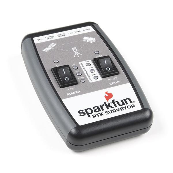
The SparkFun RTK Surveyor is an easy to use GNSS receiver for centimeter-level positioning. Perfect for surveying, this preprogrammed device can also be used for autonomous driving, navigation, asset tracking and any other application where there is a clear view of the sky. The RTK Surveyor can also be used as a base station. With the flick of a switch, two RTK Surveyors can be used to create an RTK system capable of 14mm horizontal positional accuracy. The built-in Bluetooth® connection via an ESP32 WROOM enables the user to use the RTK Surveyor with their choice of GIS application on a phone or tablet. The built in battery allows field use for up to four hours and is compatible with common USB battery banks.
The RTK Surveyor works with common GIS software for Android and iOS including SW Maps Android / iOS, Field Genius, SurvPC, Survey Master, Vespucci, QGIS, QField, and any GIS software that supports NMEA over Bluetooth.
This device can be used in four modes:
- GNSS Positioning (~30cm accuracy)
- GNSS Positioning with RTK (1.4cm accuracy)
- GNSS Base Station
- GNSS Base Station NTRIP Server
In Position mode the device receives L1/L2 signals from a user-provided antenna and the high-grade GNSS receiver provides lat/long and altitude with accuracies around 300mm.
In Positioning with RTK mode the device receives L1/L2 signals from the antenna and correction data from a base station. The correction data can be obtained from a cellular link to online correction sources or over a radio link to a 2nd RTK Surveyor setup as a base station.
In Base Station mode the device is mounted to a temporary position (like a tripod) and begins transmitting correction data over a radio or internet connection. A base is often used in conjunction with a second unit set to 'Positioning with RTK' to obtain the 14mm relative accuracy.
In Base Station NTRIP Server mode an antenna is mounted to a semi or permanently fixed position (like a roof), a cable is run indoors, and the device connects over WiFi to transmit the correction data to a NTRIP caster so that any rover can access the correction data over a cellular or internet connection. This type of base is a very easy way to setup a very precise absolute correction source.
Two cables are provided with the RTK Surveyor allowing a user to plug on our easy to use Serial Telemetry Radios or their own radio link. If a local correction source is within 10km, a user can also use their phone to provide correction data over the Bluetooth® link (no external radio needed!).
Note: The SparkFun RTK Surveyor is just the enclosed device and does NOT include an antenna, serial telemetry radio, or associated mounting pieces. These items will need to be purchased separately from the Hookup Accessories below.
Features:
Supported GIS Data Collector Software:
- SWMaps (Android and iOS)
- Field Genius
- SurvPC
- Survey Master
- Vespucci
- QGIS
- QField
- Any GIS software that uses Bluetooth SPP or BLE
GNSS Receiver: ZED-F9P
- Concurrent reception of GPS, GLONASS, Galileo and BeiDou
- Receives both L1C/A and L2C bands
- Current: 68mA - 130mA (varies with constellations and tracking state)
- Time to First Fix: 25s (cold), 2s (hot)
- Max Navigation Rate:
- PVT (basic location over UBX binary protocol) - 25Hz
- RTK - 20Hz
- Raw - 25Hz
- Horizontal Position Accuracy:
- 2.5m without RTK
- 0.010m with RTK
- Max Altitude: 50km (31 miles)
- Max Velocity: 500m/s (1118mph)
Bluetooth® Transceiver: ESP32 WROOM
- Xtensa® dual-core 32-bit LX6 microprocessor
- Up to 240MHz clock frequency
- 16MB of flash storage
- 520kB internal SRAM
- Integrated 802.11 BGN WiFi transceiver
- Integrated dual-mode Bluetooth® (classic and BLE)
- Hardware accelerated encryption (AES, SHA2, ECC, RSA-4096)
- 2.5 µA deep sleep current
Overall Device
- Internal Battery: LiPo 1000mAh with 500mA charging
- Radio Port: 3.3V TTL Serial (57600bps RTCM TX/RX)
- Data Port: 3.3V TTL Serial (115200bps NMEA)
- Weight: 132g (entire device including battery)
- Dimensions: 118mm x 79mm x 30mm (4.7in x 3.1in x 1.2in)
- 1x Qwiic Connector
- 1x microSD Socket for optional logging
- Works with common GIS software including: SW Maps, SurvPC, Field Genius, et al.
Changes: This version (which replaces SPX-17369) uses a reinforced edge mount SMA connector for better resiliency when a fixed 'stub' antenna is used.
Documents:
- Hookup Guide
- RTK Product Manual
- Schematic
- Eagle Files
- Firmware Repo
- Hardware Repo
- Learn More About RTK Surveyors
Videos
Properties
Delivered in 5 to 10 days
Customer questions
Customer Reviews
- Hobby Motor - Gear € 2,80 View product
- DC Barrel Jack Plug - Male € 0,95 View product
- Mini Pushbutton Switch € 0,35 View product
- Deans Connector - M/F Pair € 0,95 View product
- SparkFun SOIC to DIP Adapter - 8-Pin € 3,90 View product
- Toggle Switch € 2,15 View product
- Pro Micro - 5V/16MHz € 21,45 View product
- Battery Holder 2xAA with Cover and Switch € 1,35 View product
- Thermal Tape 4x4" Square € 2,- View product
- Panel Mount USB Micro-B Extension Cable - 6" € 3,20 View product
- Diode Rectifier - 1A, 50V (1N4001) € 0,35 View product
- SparkFun SOT23 to DIP Adapter € 0,70 View product
- Qwiic JST Connector - SMD 4-Pin (Vertical) € 1,45 View product
- Raspberry Pi GPIO Male Header - 2x20 € 0,95 View product
- Piezo Element € 1,75 View product