









SparkFun 9DoF IMU Breakout - IM19
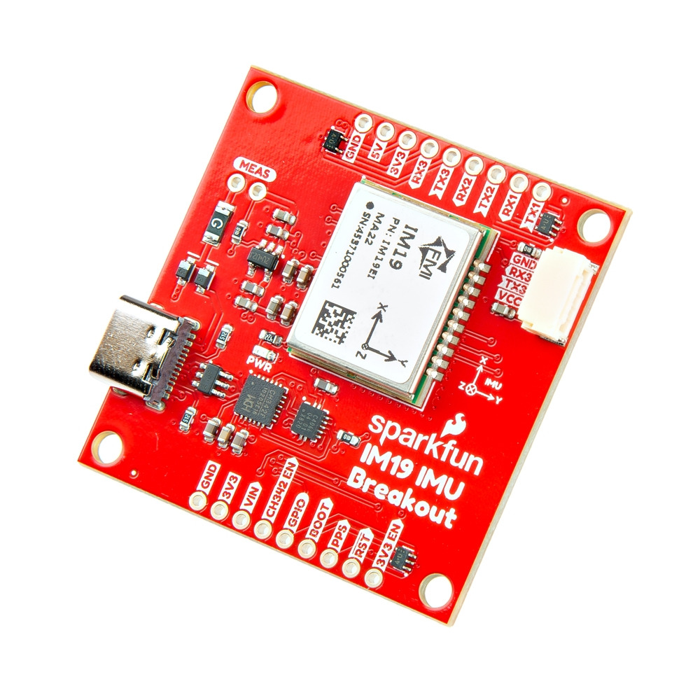
Description
In practical applications, this IMU excels in scenarios demanding survey-grade accuracy. When paired with a compatible RTK setup, it provides roll and pitch measurements accurate to within 0.05 degrees. This precision enables tilt-compensated surveying, allowing for faster field data collection without the need for perfectly vertical survey poles. It also supports continuous Dead Reckoning navigation, maintaining reliable navigation even when GNSS signals are temporarily lost, making it ideal for urban or obstructed environments.
To begin using the IM19, input NMEA GGA, GST, and RMC messages at 5Hz, along with a standard Pulse-Per-Second (PPS) timing signal. The board outputs a proprietary NMEA ASCII GPFMI message, which includes the compensated position of your survey pole's tip, along with the precise roll, pitch, and yaw of the IMU.
The hardware design is user-friendly and modular, offering flexible access to the IM19's UART interfaces. The dual USB-UART interface, locking JST connection, and breadboard prototyping options cater to various build requirements. Power the board via USB, the 5V VIN pad, or an external 3.3V supply. Its 4.3 cm x 4.3 cm PCB footprint aligns with standard RTK GNSS boards, facilitating easy stacking with existing receivers. The IM19 chip's central placement simplifies LEVER_ARM calculations, with a Z-origin of 1.6 mm above the top surface and 3.2 mm above the bottom surface.
Properties

Delivered in 5 to 7 days
 SparkFun 9DoF IMU Breakout - IM19 Delivered in 5 to 7 days € 292,75
 Customer questions
Customer Reviews
- Reduced In stock -49 % Sparkfun LED - Ultraviolet € 2,15 € 1,10 View product
- Reduced In stock -50 % Sparkfun Diffused LED - Yellow 10mm € 1,10 € 0,55 View product
- Reduced In stock -50 % Sparkfun 555 Timer € 1,50 € 0,75 View product
- Reduced In stock -50 % Sparkfun Screw Terminals 5mm Pitch (2-Pin) € 1,60 € 0,80 View product
- Reduced In stock -50 % Sparkfun Diode Rectifier - 1A, 50V (1N4001) € 0,40 € 0,20 View product
- Reduced In stock -50 % Sparkfun Battery Holder 2xAA with Cover and Switch € 2,50 € 1,25 View product
- Reduced In stock -49 % Sparkfun Reed Switch € 3,25 € 1,65 View product
- Reduced In stock -50 % Sparkfun Transistor - NPN, 50V 800mA (BC337) € 0,80 € 0,40 View product
- Reduced In stock -49 % Sparkfun Rocker Switch - SPST (right-angle) € 3,95 € 2,- View product
- Reduced In stock -50 % Sparkfun Solder Leaded - 15-gram Tube € 5,65 € 2,85 View product
- Reduced In stock -50 % Sparkfun Coin Cell Battery Holder - 20mm (PTH) € 2,50 € 1,25 View product
- Reduced In stock -50 % Sparkfun Flexible Qwiic Cable - Breadboard Jumper (4-pin) € 5,75 € 2,90 View product
- Reduced In stock -50 % Sparkfun Barrel Jack Power Switch - M-F (3") € 5,- € 2,50 View product
- Reduced In stock -50 % Sparkfun Female Headers € 2,80 € 1,40 View product
- Reduced In stock -50 % SparkFun Voltage-Level Translator Breakout - TXB0104 € 8,50 € 4,25 View product
Recently viewed items